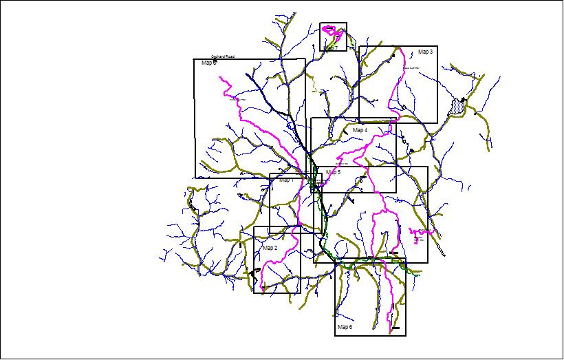
The Strafford Trail System consists of 30 miles of trails described here in 8 maps. Most of the trails are made possible by private land owners who host the sections of the trail passing over their property. Landowners have agreed to allow human powered traffic on their trails which includes foot, snowshoe, skis, and bicycle though the trails are not wheel friendly or conducive to anything but foot traffic. Bicycles with motors are NOT exclusively human powered. No motor vehicles (including electric motors) please unless specifically permitted by the land owners. Please STAY ON THE TRAILS.
The trail system is a resource of the Town of Strafford and is managed by the Strafford Conservation Commission.
The trail system is a resource of the Town of Strafford and is managed by the Strafford Conservation Commission.
This consist of about 3 miles of looping trails with significant natural orchid and animal sign viewing.
Map 7 covers the separate trails in the Cobb Town forest near the north end of Hemenway Road.Included is a Taylor Valley connector trail and a separate 1.9 mile loop in Taylor Valley.
The
Cross Town Trail runs from the highest point on Old City Falls Road to
the Sharon town line in 4 maps. It connects the 35 mile Cross Rivendell
Trail to the Norwich Gile Mountain area and trails. It is all woods
hiking with no class 3 roads. Maps 2,4,5,6 cover the 10 mile Crosstown Trail. The Richardson Hill route is included on map 5.
Town House Trail Description and maps
Town House Trail Description and maps
Maps
1 and 2 cover the Town House Trail which runs from the village of
Strafford near the Town House to the highest point on Rt 132 on O'neil
Road - 4 miles.
The two trails are connected buy the Morrill Link starting at the Justin Morrill Homestead - Map 5 - 2.2 miles
The Coburn Trail is a very short walk to a scenic overlook above the Justin Morrill Homestead.
Good management includes understanding types, times and volume of traffic on the trail system. Monitoring cameras are often used to gather this type of data. We need to understand where trail maintenance needs are greatest and anticipate problems before they arise.
No State, private or federal grant money was used in this trail system. It is totally the work of volunteer individuals and private gifts.
------------------------------------------------------------------------------------------------------------------------------------------------------------------------------------
If you use a cell phone a guided trail map is available here. It is a georeferenced PDF file. You must first load a free application called Avenza . Then send this file to Avenza on your phone. No cell connection is needed to use this tool.
Avenza will show you exactly where you are on the trail all the time your are hiking using GPS signals and this pdf file. See below for details.
See the trails on Google Earth..
Click on the file to the right to open a trail map in Google earth. You must install Google Earth first and either save the file or go directly into Google Earth.

|
TownhouseTrail_2022_1_26.KML Size : 121.067 Kb Type : KML |
Below is the key to the seven maps of the trail system
Dogs
Dogs are welcome on the trails. They should have a good time too. Many trails systems exclude dogs or require full time leashes. If you are considerate of others we won't try to impose this requirement. All this means is that your dog should be in sight and come when called. He should not be aggressive with other dogs or jump on people. If he is unpredictable just leash him when other travelers come into sight.
Using Avenza
Avenza can tell where you are on the trail at all times. First you must get a free copy from your AP Store.
You should get an icon like a red lollipop on a green background. Open it and disregard invitations to register.
You should come to screen headed My Maps. There should be no .pdf maps in it unless you've already moved some in. Avenza only allows 3 maps at once. If you already have the maps go to step 4.
You can delete a map by tapping a map once and then tap the circled "I" button and then use the trash can at the bottom. New ones won't load if there are 3 already there (unless you register and pay).
2 To get a Strafford Trails map browse your cell phone to this site -straffordtrails.yolasite.com and select one of the map files below. There is one for the northern trails and one for the southern trails. Now you want to share it with Avenza. With the map visible I hit the (...) simbol at the top and it brings up a menu and a "share page with.." option is at the top. Tap this option and a page of applications will appear. Swipe through them till you see the Avenza symbol and select it. The My Maps screen should open and the new map will appear on it.
3 Alternatively you can mail the map to your device as an attachment, open it and pass it to Avenza. Just tap the little box with an arrow out of it and select Avenza.
4 In the My Maps screen tap the map you want to use and Avenza will open it and locate you on it if your position is there. This last step requires no cell connection. The GPS system and Avenza will track you down any trail or road you follow. Don't worry if it complains about missing a compass. It isn't necessary.
Happy trails.

|
Northern trails.pdf Size : 6436.911 Kb Type : pdf |
|
|
Southern trails.pdf Size : 5035.532 Kb Type : pdf |